![]()
Erie
County History
New York
|
Reprint
EC 200 | A Brief History of Erie County Before It Was Established by Charles Skowronski Buffalo Rising, May 31, 2021  "Various historical, ethnohistorical, and cartographical evidence combines with the archaeological data to suggest that during the seventeenth century there was a concentration of Iroquoian groups in the Niagara region. These sources indicate that several smaller and less well-known Iroquoian groups shared the region with eastern elements of the Neutral and Erie confederacies."1 The Neutral nation occupied much of what is today’s Southern Ontario and parts of the southern shore of Lake Erie. It was circa 1650 when the Neutral nation was defeated by the Senecas. “It is believed that the scene of their final defeat was near the city of Buffalo.” 2  Le Loup, Antoine, Artist. Vue
du cataracte de Niagara, au pais des Iroquois / Antoine Le Loup fecit.
New York Ontario Niagara Falls, 1770.
The first Europeans were under French explorer Robert Cavalier De La Salle. His expedition had set out to explore the Ohio and Mississippi Rivers via the St. Lawrence Seaway. While the expedition would not reach its goal, it did make it to the Niagara River, where a trading post was established in 1678. The French had allied themselves with the Algonquins and as a result had made enemies of the Five Nations, who had been successfully trading with the English, as they expanded their colonies up the Hudson River. These hostilities would result in a series of skirmishes between the French settlements and the Five Nations. The French were able to slowly gain favor with the Senecas thanks to Louis-Thomas Chabert de Joncaire, who had been captured. Joncaire would go on to learn the Seneca’s language and act as an ambassador to French colonial interests. With the French having established a foothold on the southern shores of Lakes Erie and Ontario, this would add to growing tensions with the English, who had claimed all territory south of the Great Lakes. Both would be pulled into the French and Indian War in 1754, which would end in 1763 with English victory and the expulsion of the French from their North American colonies. At this time, the Western portion of the state was owned by the Seneca Nation. "In 1787, Oliver Phelps had purchased the right of preemption from Massachusetts…in June 1788, he met the Senecas at Buffalo, and concluded a Treaty by which they conveyed to him the territory lying between the pre-emption line and the Genesee River, and a strip of land on the west bank of that River, twelve miles wide and about twenty miles in depth from mouth." 3 This was known as the Phelps’ and Gorham Purchase. At the same time, the Constitution of the United States was in the process of being ratified. With the Revolutionary war and establishment of the United States, people slowly began to emigrate west. By August 1797, the Holland Land Company, through its agent Joseph Ellicott, was in the process of acquiring the remaining lands. What enticed people were the “cheap and fertile lands of Western New York.”3 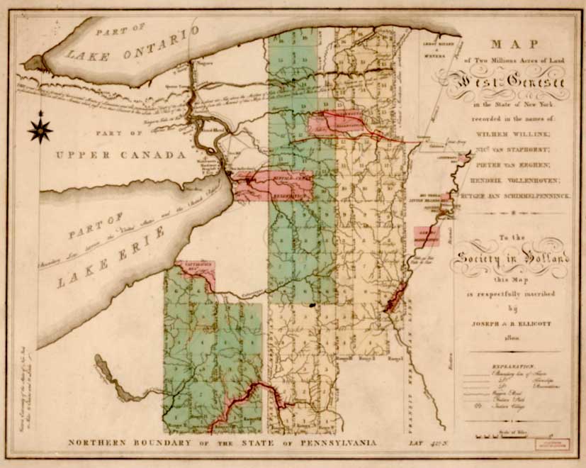 Library of Congress, Geography and Map
Division.
By this time two burgeoning towns had begun to spring up in this region, Blackrock and Buffalo. With the act of March 11, 1808, the County of Niagara was established, which consisted of modern day Niagara and Erie counties. It was also at this time that the change of the name of the “Tushawa or Tehoseroron to Buffalo Creek”3 occurred. This act also mandated that a courthouse and jail be erected in the village of Buffalo. Buffalo and Blackrock would not escape the ravages of the War of 1812. "The village was undoubtedly doomed to utter destruction. During the last war our citizens had rendered themselves obnoxious to their Canadian neighbors…on the 30th of December 1813, a large British force with a horde of Indian auxiliaries, crossed the river at Black Rock, advanced upon the village and took and burnt it, despite the gallant resistance of a portion of the inhabitants. Many of our people were carried away captive, and those who escaped, fleeing as they did in the depth of the destruction that only two dwellings were left unconsumed." 3 It wouldn’t be until 1815 that rebuilding would begin, after the war had ended. From that point, the population of the region slowly began to increase. In 1817 construction of the Erie Canal, which would provide the Great Lakes region with a more efficient way to transport goods to the East Coast, began. It would be because of the canal, completed in 1825, that would allow for the region to prosper and grow. In 1821, Erie County was created, splitting with Niagara County. The county encompassed the land between the Tonawanda and Cattaraugus Creeks. The first towns included the towns of Clarence, Amherst, Aurora, Boston, Holland, Sardinia, Collins, Concord, Hamburg, Wales, Eden and Evans. 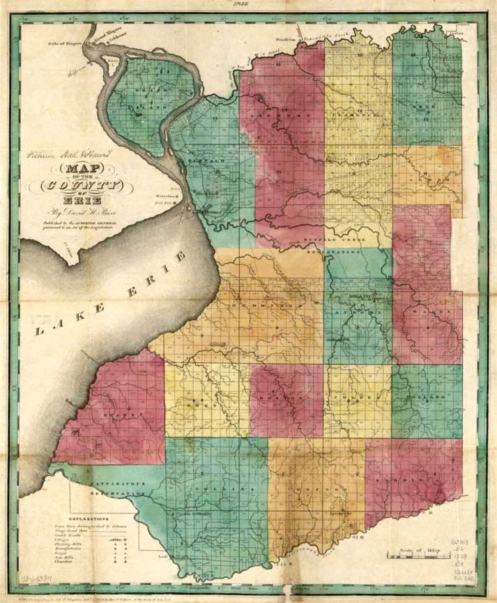 Library
of Congress, Geography and Map Division
Erie County would continue to grow and become a large metropolitan area well into the 20th century. This is just a brief glimpse at our history, if you want to learn more, I highly recommend checking out some of the sources I used, listed below. 1. 2222Pendergast, James F. “The Kakouagoga or Kahkwas: An Iroquoian Nation Destroyed in the Niagara Region.” Proceedings of the American Philosophical Society 138, no. 1 (1994): 96-144. Accessed May 10, 2021. 2. Lionel Pincus and Princess Firyal Map Division, The New York Public Library. “City and Town Histories.” New York Public Library Digital Collections. Accessed May 26, 2021. 3. George W. Clinton: “Early History of Buffalo by Hon. George Clinton.” New York Heritage Digital Collections. Accessed May 1, 2021. Photo Credits in order of appearance, Top to Bottom. 1. Two people on rocks overlooking the waterfalls at Niagara Falls: Le Loup, Antoine, Artist. Vue du cataracte de Niagara, au pais des Iroquois / Antoine Le Loup fecit. New York Ontario Niagara Falls, 1770. [Between ? and 1840?] Photograph. 2. Original Purchase by the Holland Land Company: Ellicott, Joseph, Benjamin Ellicott, Wilhem Willink, C. Van Baarsel, and Holland Land Company. Map of two millions acres of land, West Genesee, in the State of New York: recorded in the names of Wilhem Willink, Nic’s van Staphorst, Pieter van Eeghen, Hendrik Vollenhoven, Rutger Jan Schinnelpenninck. [Amsterdam?: Van Baarsel, 1800] Map. 3. 1829 map of Erie County: Burr, David H, and Millard Fillmore. Map of the county of Erie. [N.P, 1829] Map. |
Page by Chuck LaChiusa
in 2021
..| ...Home
Page ...| ..Buffalo
Architecture
Index...| ..Buffalo
History
Index...| .. E-Mail ...|
..